Local Walks
The Henbury Society have described a series of local walks. We advise the use of an Ordnance Survey map in conjunction with the walk details, and please be aware that some details may have changed over time. If you are aware of any changes, please contact us here.
December 2018
A new "Christmas Walk" has been added, courtesy of David Walker.
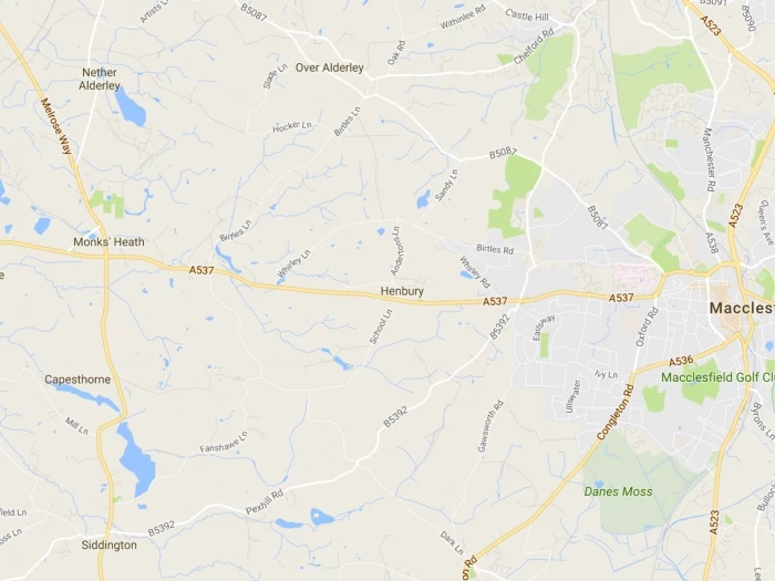
A linear walk. 4 miles, easy. 2 hours Either westwards from the village to Monks Heath, ending at Alderley Park, AstraZeneca and telephone for a lift home, or Persuade your driver to drop you at Alderley Park (ref 844 746), and walk back to Henbury. We describe this eastwards route. At AstraZeneca turn left towards traffic lights for 20m and turn left through gap in wall to a stile in 50m. Over the stile go straight on up the field to a stile by a post on the crest. Alderley House used to be the seat of the old County family, the Stanleys. They moved there after a disastrous fire in 1799 attheir earlier home near Alderley Mill. This house too was destroyed by fire and demolished in 1933. The family then lived in their farmhouse next to the surviving tenants' hall until the estate was sold in 1938. Straight on to stiles in "phantom fences" (views of Shuttlings Low and Sutton Common). Keep up then follow fence on left to pass to the left of Fernhill Farm by a series of stiles. Go straight on down to pass to the right of a pool in a copse and on with a fence on left to a stile, followed immediately by a second. Here go left following the field edge to the bottom left of the field where you go right for 40m to a stile by a gateway. Keep the copse on your right, then a hedge, then a fence until you reach a gate on the right leading to the imposing Birtles Hall. This is the new Birtles Hall. The Hibbert family, after a fire partially destroyed their home at what is now called Birtles Old Hall, situated on a neighbouring site, built this large hall in 1796 on the Pasture Estate. It replaced an earlier dwelling here. Colonel Hugh Hibbert who served in every battle in the Crmean War lived at Birtles New Hall until the late 1880's. The Hall is now divided into apartments. Here you go left following the fence on right up field to pass a pond in a copse (Many such ponds were dug to spread marl over the fields; hence the name Marlheath Farm). Go straight on across the next field to a stile 50 m to left of lone tree. Proceed with fence now on left and over another stile in 80 m. The path now curls half right to take you up to hedge line leading to the left of Higher Park Farm to a stile by gate to the right of stables. (Here a right turn would take you to the Church at Birtles; see below). Go left up the track to pass farm cottages to a junction in 200 m. (Straight on, Slade Lane, takes you up to The Edge via path on left at top of hill: left takes you down to Bradford Lane and so on to the A34 in Nether Alderley). Go right up Hocker Lane for a little over 200 m to a well marked path on the right immediately beyond a wood. Drop with the wood on your right, through a wooded dell and up steps to a field. Go left and with fence on left (views of the Lovell radio telescope at Jodrell Bank on right) you come to a stile out to the road. This is Birtles Lane. St Catherine's Church at Birtles is in the ecclesiastical Parish of Over Alderley, but not in our civil Parish. It was built by Thomas Hibbert of Birtles Hall after he quarrelled with the Vicar at Over Alderley. Go right for 30 m then left along a farm access road (to Highlees Farm) for 250 m. Ignore the first unmarked stile on left. The road crosses a stream in a deep clough. As you rise up out of the dip there is a stile high up on the left just at the end of the wood. Follow the field edge up and round to the right to a stile . Drop down left to a track and along with a clough on right (a veritable rabbit warren) to a stile by a gate in 100 m. Go right up into the field and make for the left of a pair of trees and on to a gate in the muddy patch at the right hand corner of the field. Go over the stile by the gate down a track and curl left up to a stile ahead as the track bends off to the right. Over the stile go up across the field aiming for a stile in the hedge slightly to the left of the most right of the Whirley Farm buildings. This brings you out onto Wrigley Lane. Turn right down to a junction, crossing the Henbury Parish boundary just before you reach the junction. Whirley Hall is on your right. This handsome building, built in the early part of the 18th century was the residence of the Birtles and the Swettenham families. There used to be a small black and white building to one side, which was demolished before 1871, and was probably the original hall. Go left on Whirley Lane and in 150 m turn right into Anderton's Lane (or go straight on to a path on right beyond the water tower). Continue down the lane to The Mount. The Mount consists of a house, probably dating from the time of George III, and Mount Farm, known in 1764 as Lathams tenement. Andertons Lane was named after Samuel and his son Edward Anderton who occupied and probably built the house circa 1799. Here you can either turn left (see below) or go straight on to Church Lane and Dark Lane, passing High Trees on your right. Note the date plaque on the cottage which reads W.J.H. 1760. The initials probably refer to John Wainwright, chapman, who married Hannah Bibby, widow, at Prestbury in 1763. Confusingly, another cottage named High Trees lies on the corner between Andertons Lane and Dark Lane. Church Lane on the left, and Dark Lane on the right are part of an ancient track from Broken Cross to Chelford. From the bottom end of Dark Lane, it led across open ground to join what was then the 1769 turnpike road from Broken Cross, now called Whirley Lane. It joined Whirley Lane immediately behind Pale Farm, a 14th century timber framed building. A new turnpike road, which is now the A537 was built in 1808 to replace the 1769 turnpike. Alternatively, at The Mount, turn left down an access track. When you reach the cottages, go right to pass below them, and right at the kissing gate before the pylons which will take you behind gardens and out onto Henbury Drive and so left back to the Church and the Millennium Green. At the cottages you can instead go either left or straight on across the fields to Whirley Road.
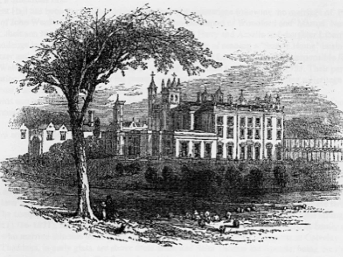
Easy, with some road walking and a useful shortcut. This is a circular walk: start anywhere and go either way. We describe it counterclockwise, starting at Redesmere (G.R. 850 715) where parking is easy. We also describe two possible extensions, of one and two miles respectively. From the Redesmere duck-feeding area walk S.E. towards the A34. 50 m beyond the end of the mere go left over a stile by a gate. Follow the field edge to another stile and go half left up to a stile 50 m to the right of the top left corner of the field. Continue along the same line, making for the leftmost of the trees ahead, to a stile by a gate out onto the B5392 road by Simonswood Farm. Go left on the road for 1 km. Opposite Henshaw Lane on the right, take the stony access track on the left just before a house. There is a path to the left after 200 metres; this is theshortcut* which we describe below. Straight on, follow the track to pass Hazelwall (3 houses) on left and curl left round the last one of these through a kissing gate into a short wooded lane leading to a stile. Over the stile drop down a field to a stile in the copse and cross Fanshawe Brook by a footbridge and another stile. Fanshawe Brook is the Parish boundary between Siddington and Henbury. Originally it was fed by the Bag Brook (behind the Cock Inn), but in 1717 William Meredith of Henbury Hall diverted the Bag Brook into his estate to feed a water mill, to the annoyance of John Ward whose Capesthorne mill was fed by Fanshawe Brook via Redesmere. Climb the field with hedge on left and, at the top with farm buildings on the right, go over a stile to Fanshawe Lane. The next lane to the right has a short connecting footpath to Sandbach Farm, and on to Huntley Wood and Bearhurst. The lane leads on to Henbury Moss Farm, with another footpath leading south to Thorneycroft. Opposite the lane are Fanshawe Cottage (the home of Maria Rathbone, whose tragic death aged 8 on a shopping expedition in December 1822 is recounted in the Henbury History) and Apostle Cottage, which once housed a Sunday School: the yard between the two cottages used to be called Hallelujah Square! Continue north on the road, past a track on the right (to Sandbach Farm) and on for another 400m to Lingards Farm on the left. Henbury Moss, with its closely packed farms and cottages is believed to be the oldest part of Henbury. The earliest record of Lingards Farm, where the house once contained wattle and daub, is a lease by Sir Fulk Lucy and Dame Isabella of Henbury Hall to John Harrop in 1667. The premises were conveyed in 1713 to John Lingard, a blacksmith of Monks Heath. Later the farm was sold to the Capesthorne estate, and a recent occupant thought that an earlier tenant used to do the Capesthorne laundry. Take the rough track to the left on the far side of Lingards Farm and over a stile by a gate. You are now on an ancient carriageway from Capesthorne to Macclesfield. Continue with the hedge on your right to another stile in 15 m. Keep the hedge on your right and in 100 m you come to a green lane. Stay on the track at this point (ignore the stile a little to left). You pass a track to Marlheath Farm on right. Marl Heath, or Marl Earth Farm is a timber framed farmhouse, dating back at least to the 17th century, when it was called Cragg's Tenement. At various times it has been owned by the Henbury and the Capesthorne estates. Keep with the track to pass Henbury Lodge and in ¾ Km you come to the A34 opposite Capesthorne East Lodge. Capesthorne, the seat of the Bromley-Davenports (open to the public at certain times) is worth a diversion. The present house, built in 1722, replaced a 15th century building nearby. The Davenport and Ward families, ancestors of the present owners are believed to have lived on this site since Domesday times. Go left on the road for ½ Km and where the road bends right go left on a track, through a gate and so to Redesmere on your right. When the fence on the left curls off left go straight on towards the Sailing Club entrance. Pass the entrance to a facing gate ahead to a path through trees. Fanshawe Vicarage can be glimpsed through trees on the left. Although it used to be the vicarage for Siddington, it actually lies within Henbury Parish. A vicar's son, Wilfrid Elstobb who lived here was awarded the D.S.O. in 1917 and a posthumous Victoria Cross in March 1918 for valour on the front line at St Quentin. Go over a footbridge and in 50 m, when the bridle path goes off left to Fanshawe Brook Lane, go straight on over a stile to a path which takes you between fence and wood to another stile and on across field to a stile out on to the road. Go right and back to the car: there is usually an ice-cream van as a reward!). *The shortcut from Hazelwall is a direct route across fields, well marked by stiles, to a muddy crossing of Fanshawe Brook at the start of Fanshawe Brook Lane, which leads to Fanshawe Vicarage and the end of the main walk. On this lane there are some attractive thatched cottages, including Glebe Cottage which must at one time have belonged to Siddington Church. Extension 2a. Start from Redesmere by walking south 300 m along the A34 and turn left on the B5392. After 80 m take the driveway to Siddington Church on the right, and on down a path facing the porch, through a gate into a field. Go slightly right across fields via 3 stiles; over the third go down the field leaving the fence on the left to reach a stile by a pond. With the bank on your left, cross a stile on your left and make for Northwood Farm. Take the stile just before the farm gate, skirt the farm and turn left along a farm track for 1 Km to Marton Lane. Follow Marton Lane to the left for 400 m; just before a wood turn left on a track to Crabtree Moss Farm. Go through the farm yard and through a facing gate. Follow a hedge and take the track to the right through two gates. Approaching Henshaw Hall Farm, ignore a path to the right, and after 100 m turn right, through the farm outbuildings to the access road, which becomes Henshaw Lane. Cross the B5393 to rejoin the main walk.
Bluebell Wood and Sandbach Farm This short round (1½ miles) can be taken as the turnaround of a walk down School Lane, or a car can be parked at the entrance to Sandbach Farm (ref 865 726). From School Lane walk along Bearhurst Lane (opposite the back gate to Henbury Hall). After 400 m a footpath on the right leads from the south end of Bluebell Wood (Huntley Wood), across the fields to Sandbach Farm. Here there are links to Walk 2. Sandbach Farm displays a 1641 date plaque. From 1700 it was farmed by three generations of the Sandbach family who were also tanners. In 1734, Samuel Sandbach was an Overseer of the Poor for Henbury. Turn right and take the farm road to the parking spot on School Lane. Here go right to complete the walk.
Redesmere and Blake House Farm. 3 miles, easy. (see map for walk number 2) Park on the south side of Redesmere, and walk east along the lane. Just beyond trees at the water's edge, take a style on the left which leads to a path which crosses a meadow on the east side of the lake, then a second style to a kissing gate. Do not take the path to the right, but continue north through trees, through another gate with the sailing club on your left. Follow a track along the Redesmere bank until about 20 metres before the track joins the main Congleton Road (A34). On your left, a stile leads to a path across the northern end of the lake. Cross the main road (A34) to a stile opposite, and walk with a fenced wood on your right. Another stile leads to meadows bordering two Capesthorne pools on your right. Continue to a kissing gate, across the private drive (which crosses a bridge, built c. 1843 over the pool). Continue north to Mill Lane, and over a stile opposite. Bear left across the meadow and two further stiles. Cross a muddy cart track, through a field gate and stile opposite, and turn left. Keeping the hedge on your left, and now moving south, cross 3 stiles making for Blake House Farm diagonally across another field. Walk down Blake House Farm track and take the first lane on your left. This leads to a path running along the edge of a wood, situated in a deep hollow on your right. At a junction, turn left past a small holding (barking dog!) and continue until you reach the A34, where you turn right along the footpath. Cross the A34 to follow the first lane on your left to return to your parked car.
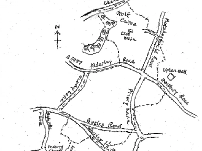
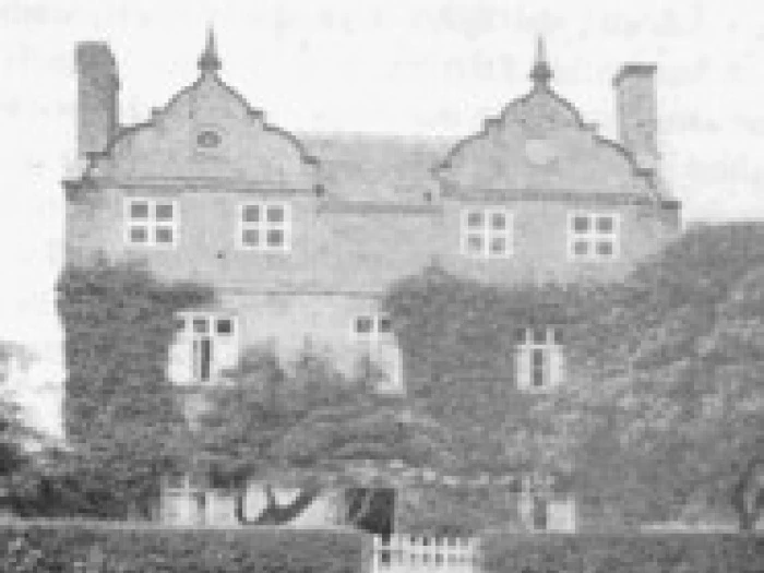
Upton Hall, Prestbury Golf Club and Sandy Lane – Starting from St Thomas' Church G.R. 881 736 Go north up Henbury Rise (don't turn into High Trees Drive) and just before end take a ginnel on right which passes behind gardens, through a kissing-gate and in 100m to another gate on right in frontof houses. Follow this path across the common and up to Whirley Road. Turn right. Then in 300m turn left into Newquay Drive. Cross road and in 80m drop down steps on right to path behind gardens then school playing fields. At end of railings go slightly left and follow beech hedge then tarmac path to road. Go slightly right across road into Truro Close and on along tarmac path to Birtles Road. Go right for l00m then left along Priory Lane for 350m where , just opposite the end of the Leisure Centre, you will find Becks Lane. Upton is an ancient township referred to in Court Rolls of 1285. The 1904 OS map shows three large houses, (Grange, Priory and Hall) and little else. Becks Lane was the access to Upton Priory, now demolished, which was a large house owned by the Beck family in the 19th century. In the 17th century it was a farm owned by the Wright family, a number of whom were mayors of Macclesfield. Only gate posts and a fallen mounting block now remain. When this stony lane passes a playing field on the left, go straight on along tarmac path which winds through the estate and eventually out to the main Prestbury Road opposite Upton Hall. A Saxon Cross on Prestbury Road possibly marks the ancient boundary of Macclesfield. Look for an iron pole on the right as you approach the Priory Lane crossroads. Quite close, behind the hedge, is the stump of the cross. Turn left and just beyond Upton Grange cross road to stile into fields. Go just to left of pylon then to left of line of trees and down to facing stile. Over this turn right. When hedge on right turns off even more right, go straight on up field to tree and stile to left of gateway (or through gateway if tired of stiles).Turn left and keep fence on left for 400m when you drop down to Macclesfield Road. Go right for 40 m then left up the drive to Prestbury Golf Club. Ignore first path on right but go on to top of hill and turn right down path on far side of last house (opposite imposing iron gates) and so to course in 50m. Turn right and with wood on right descend to bunker and curl left through copse, pass below tee, and on through another copse ahead. Go straight on past next tee (don't fork off right) and steeply down to pick up hedge on left and line of trees on right. Follow the clear path for 250m to kissinggate out to Chelford Road. Turn left and up road for 450m. Pass the white stones outside Thieves Hollow and in 80m, as you round left-hand bend, take broad path on left. Follow this tree-lined avenue down for 300m and cross footbridge and on up to stile out of wood. Go right for 200m with wood on right and, 50m before fence ahead, turn off left up to stile in top right corner of field. On for 50m to another stile on right under tree. Cross this and proceed with fence on right for 250m on to stile under second stile on right. Take this and go left to pass between farm and houses to a squeezer stile on left just before the main road. Go right along the pavement for 50m then cross the road to the grass and go on with fence on left for 400m where you turn left down Sandy Lane as the main road bends off right. At the end of Sandy Lane either go right for 200m to Andertons Lane or turn left for 200m and go right over wall immediately beyond renovated flats and houses. Follow the fence up for l00m, go straight past gateway and in 50m take the stile in the hedge on your right. Go left and follow fence down to a stile at bottom of field. Go left along access drive towards houses, then right and left below them. Turn right in front of the kissing-gate and so back to Henbury Rise and the church. Nether Alderley Water Mill This 16th century corn mill was still grinding corn up to 1939, and was restored by the National Trust from the 1950s. An earlier mill was recorded in 1290. It consists of two overshot wheels. The timbers bear the marks of the Elizabethan carpenters. Behind the mill stands what remains of Nether Alderley Hall, the seat of the Stanleys until it was largely destroyed by fire in 1799.

Nether Alderley Mill, The Edge and Finlow Hill A linear walk, 6 miles, moderate, 3 hours, with an alternative 5 mile circular walk. From The Mill cross the road. Go left for 50m then right along lane to St Mary's Church. Enter the grounds, passing the Old School House,and walk straight on past the left of the church to a gate into a field. The Old School House was built in 1628. St Mary's Church is 14th century. Note the unusual feature of an internal pew with access up stone steps from the outside, built by the Stanley family to avoid being overlooked by the congregation. The Stanleys were Lords of the manor for 500 years: their estate was sold off in 1938. Go forward to a gate and bridge over brook Turn right and across field to a stile by gate. This brings you out to where Sand Lane meets the A 34. Go up the main road for 250m and turn right up Bradford Lane. In 200m turn left over a stile, opposite a curious oval shaped enclosure, with steps leading down to a small stream, once used for watering horses. In 70m go over the stile on right and immediately left, the stream and hedge now on your left, to come out via a stile into Artists Lane. Turn right up the lane for 500m before forking off left along a broad track just before S-bend sign. Follow this gradually up for 400m. At a distinct cross track go straight on up a narrow path through gorse bushes. When this reaches trees, curl left along a wide grassy path towards a gate. Immediately in front of the gate turn right up the path with fence on left and follow this gradually up to the main road (B 5087). Go straight across and follow the path into the Alderley Edge National Trust property. The Edge is latticed with tunnels used for mining copper, cobalt and lead, in use from at least the Bronze Age. A bronze age wooden shovel, and a cache of Roman coins have been discovered at this site. After 90m a right fork brings you to Castle Rock Erosion Control measures encourage you to take a broad path along the edge of the field; at a wall you join the old path. At the next corner of the wall The Beacon is up on your right. The Beacon is shown on the Camden Map of Cheshire in 1586, and is believed to have been used to signal the approach of the Armada. There used to be a small tower on the site, and a pot of pitch used for igniting the beacon. Erosion Control seems to be persuading us not to go up over this feature, but if you imagine you have gone straight over the top of The Beacon, the path to Stormy Point is the one straight ahead and on the level. The path on the right will take you to the Beacon Lodge; the path dropping down left will also take you to Stormy Point but will miss out the miniature "Stone Circle" which is up on the right and spilling down onto the path. The Stone Circle is a folly, claimed by a famous local author, Alan Garner, to have been set up by one of his family for Lord Stanley in the 19th century. After enjoying the wonderful View from Stormy Point, turn right along the broad stony path until you reach a gate. Turn right along access track and take the path off left opposite the Rangers Cottage. Cross the field to the Car Park. Go to the left of the Toilet Block to a path going half left out to the main road. Cross road, go left then right along Bradford Lane. In 200m go left then in 400m, where the road bends left, go straight ahead through a kissing-gate and on to a stile. Keep the hedge/fence on your right and so out via a gate to Slade Lane. Go right and drop down in 500m to Hocker Lane. Go left. (Or if you are making this a circular walk, go right.) You now return to Henbury following the directions for Walk 1 given in the last few lines of page 4. The alternative circular walk (5 miles long) starts at the car park on The Edge and follows the directions from there to where Slade Lane meets Hocker Lane. It then follows Hocker Lane to join Bradford Lane, turning left back to the main road. The Mill is 300m along on the left. (Alternatively, you could go straight across Hocker Lane and down the track to reach Birtles Church. Then go left up the hill on the road for 400m and turn right along the access track to Highlees Farm.)
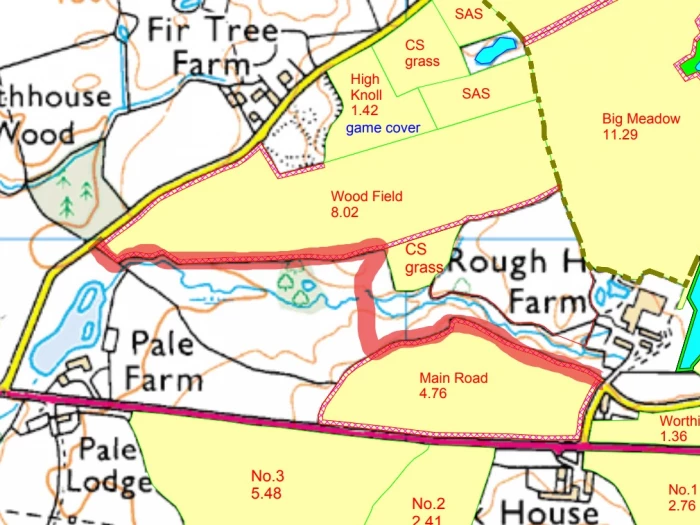
New Permissive Footpath between Dark Lane and Whirley Lane. With the kind permission of the landowner and of the farmer, parishoners now have the use of a new walk near Henbury. The walk is open between 1st February and the 31st August each year and the route is waymarked using standard white arrows. Dogs are welcome but must be kept on a short lead at all times and walkers are strongly adviced to wear wellingtons or boots. The walk runs from Dark Lane, starting just below "Old Chapter" GR875738 cross-country up to Whirley Lane, close to "High Lodge" GR872745. Walking up Whirley Lane and to wards the village via Andertons Lane provides a pleasant circular walk. DARK LANE/WHIRLEY LANE CONCESSIONARY FOOTPATH IMPROVED ROUTE. Please note that there has been a change to this route as detailed on the sketch map below. The path follows its original route along the field boundary from Dark Lane then turning left for a short section of track. The new route then turns right up a gently sloping wide grassed track to a pond in a field corner. From the pond swing left along a short section of field boundary to reach another grass track which exits via a gate onto Whirley Lane opposite cottages and closer to Whirley Hall than the previous route. Directional arrows have been posted to enable it to be walked in either direction.
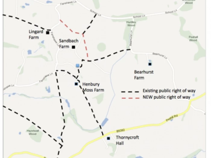
New Public Footpath from Fanshawe Lane and around Sandbach Farm en route to Bearhurst Lane. Update 2018 NB -- the footpaths around Sandbach Farm have been changed recently. View this PDF for photos to help with this route. The circuit starting from the Church is about 1.5 hours or about 40 minutes from the junction of School Lane and Bearhurst Lane at a gentle pace. (The route can be shortened by walking up the Drive and rejoining the walk at ***) Continue to pass the entrance to Marlheath on the right then look for a new kissing gat (KG) up the bank on the left about 120 yards beyond the end of the black and white Cheshire railings. Through the KG head half right keeping right of the telegraph pole in the fence ahead to reach a KG in the bottom field corner then follow the right hand hedge to another KG onto Sandbach Farm drive. Cross the drive. *** Go through the KG on the left of the drive and walk half left over the brow of the hill, keeping well left of a fenced area, to drop down to a KG in the far corner and a junction of 3 paths. Climb the stile on the immediate left and cross the pasture following a route between 2 trees and the telegraph line (yellow waymarker here) cross a wooden bridge which has a stile at each end. Turn left along the hedge boundary then right along the fence at the end of Huntley Wood to enter Bearhurst Lane at a stile behind a holly bush beside a wooden gate. Turn left along the lane to reach School Lane again.
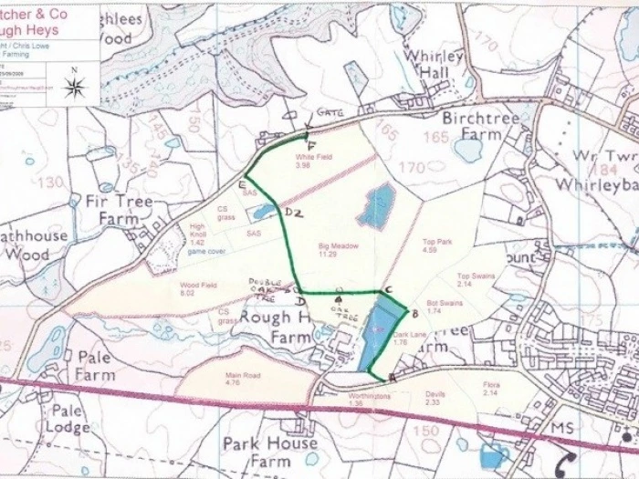
This NEW path has been defined in April 2022 to complement the existing path from Whirley Lane to Dark Lane (Walk 7) and allow a circular walking route from Henbury. It results from a collaboration between Henbury Parish Council and Mr Andrew Fletcher, the landowner, to whom great thanks are due. While it is initially open on a probationary basis, it is intended to be accessible between February 2nd and August 31st annually, if no issues are encountered. All the details are here.